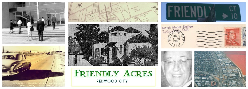

Sweeny Ranch Airport
The residential development of Friendly Acres in the early 1930s carved up the last of the ranches in the southeastern end of San Mateo County - the notable Sweeny Ranch. This was in fact the last of the Arguello marsh lands from the old Pulgas rancho.From about the 1880s the lands just south of Redwood and east of Menlo Park were known as Sweeny Ranch lands, after Myles D. Sweeny who bought the property from the Arguello estate when the Pulgas Rancho went up for sale and was subdivided. Today, the Sweeny name survives - but just barely.
You can find it in the land titles of the unincorporated properties in the Sweeny Ranch subdivision in Menlo Park, south of Marsh Road and east of Bay St. Only about a dozen houses remain today that can still lay claim to being on the historic Sweeney Ranch and they're in unincorporated Redwood City and Menlo Park.
And it continues on in the name of the train stop at Marsh Manor, which still exists today, as a flag stop station - listed in the Southern Pacific railroad schedules, as Sweeny Ranch station. Yes, that train barrier across Marsh Road is in fact a flag stop station. But more on that in another post.
And the name continues to exist in the name of Sweeney Ave, a road just off of Bay Road, opposite the Ampex campus, named after Miles D. Sweeney. [Editor's note: the variation on the spelling of Myles Sweeny's name in the historical records is common. The given spelling, based on the 19th Century census records, is without an "e" before the "y".]
Today's post, however, is not about the landowners of the rancho lands that Friendly Acres grew out of, but of the airport that we once almost became.
At the turn of the 20th century, aviation and cars were the huge technological advances which revolutionized transportation and catapulted the world into the modern era. And from 1911 thru the decade of the roaring 20's, Redwood City was THE place to be on the San Francisco Peninsula if you wanted to watch an airshow or learn to be an aviator.
In the winter of 1926 the San Francisco Airport committee had a shortlist of eight sites to visit - on both sides of the bay, with three of them being in San Mateo County: Coyote Point, Brewer's Island and Sweeny Ranch.
Mr. E. W. Holt, spokesman for the Redwood City Chamber of Commerce encouraged the San Francisco Supervisors to inspect the Sweeny Ranch site describing it as follows: "The climatic conditions are perfect, insuring perfect flying weather at all times."
Doesn't that sound familiar? It should. He was paraphrasing the "Climate Best by government Test" slogan that the City had only recently adopted in the previous year, in 1925, and had placed over their gateway arches into town.
The strategic importance of "climate" as a resource was a big deal to the Peninsula Cities who were interested in attracting San Francisco workers and residents to its green commuter belt and weekend suburban country homes. Redwood City already had the Redwoods as a business and marketing commodity in its name. Not being plagued by fog, all it needed was a branding slogan for its perfect weather. And it intended to capitalize on its micro climate as a strategic resource.
The so-called government test of 1912 was conducted in tandem with the German government, and its likely that the chamber of commerce rallied to have Redwood City submitted as a test site. And its highly conceivable that Daniel Stafford, one of the city's most influential merchants and business men, was a strong advocate for having the city used as a test site at that time. The push to market the weather with empirical findings was something that smelled of Daniel Stafford - as the city's largest merchant and a significant real estate and insurance investor he was also one of its biggest promoters. The climate slogan wasn't just about immortalizing a government report, it was about bringing in big business, big money and big residents.
The Sweeny Ranch site was a late entry to the airport selection game and consisted of 487 acres of marsh land (7000 feet long and 3000 feet wide), which Stafford had recently purchased, located along the Dumbarton cutoff of the Southern Pacific railroad. (This was the area later to be known as Friendly Acres.)
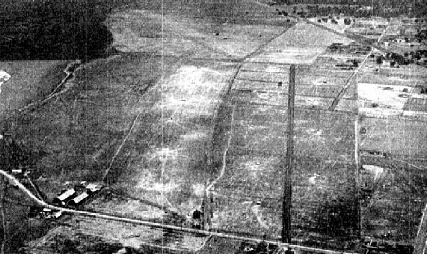 |
| Image showing Redwood City Airport / Sanders field and Sweeny Ranch lands / Friendly Acres still intact. An undated aerial view looking east from The Airport Directory Company's 1938 Airport Directory (courtesy of Jonathan Westerling). The Dumbarton rail line crosses diagonally at the top right of the photo. Image source from a fantastic site at: Abandoned and Little known Airfields: CA-San Jose area curated by Paul Freeman. |
Stafford's Sweeny Ranch airport would include the eastern end of Lynch Field, (today the Ampex lands) extending the Sanders Field air strip, which was the existing Redwood City Airport that stretched from Chestnut to Woodside Road. That eastern end went from Woodside Road to 2nd Avenue, making use of grassland that was being used for grazing cows.
Lynch field was named after Michael Lynch who had purchased a subdivision of the Sweeny Ranch from Regina Pescia (nee Regina Anastasia Sweeny, daughter of Myles D. Sweeny) in 1898, and used it as a secondary nursery location to grow flowers and cultivate seedlings for the flower trade.
Michael Lynch died in 1905, and his family sold it in June of 1916 to Silas Christofferson, the famous aviator and plane engineer who, aided and abetted by the Redwood City Chamber of Commerce, established his flying school in 1916.
Christofferson had planned to expand and develop the Redwood City airport to the southern end of Lynch field (where Broadway today continues from Woodside Rd to 5th Ave), with a view to manufacturing military airplanes. (In Europe, WWI was at its peak - and Christofferson had ideas for specialized engines and aircraft based on his experience flying for Pancho Villa's army in 1915 during the Mexican Revolution). But on Halloween of 1916, while test flying a new military plane which he had designed, over the Bay around Redwood City, the plane's engine died. Unable to coast it, the plane nose dived and he dropped 100 feet down on to Lynch field, crashing to his death just 4 months after purchasing the fields and airstrip. The young daredevil and brilliant aeronautical mechanic, was only 26. The airfield was subsequently referred to as "Christofferson field".
Following the tragedy which made international headlines, Frank Bryant who had worked for Christofferson as chief trainer of the flying school, bought out the airport property, and renamed it the Redwood City School of Aviation.
But only three years, later, in 1919, Bryant sold out to the ambitious Walter Varney who had other fields in San Mateo and had ambitions to run a postal air distribution service from San Mateo, as well as aerial taxi services.
Varney also shipped flowers by air from the greenhouses of Redwood City and was subsequently to become the founder of United Airlines and co-founder of Continental. During Varney's time until the early 30s when the land was again sold off, the air fields were also referred to as Varney's field
 |
| San Mateo Times, November 13 1926 |
Despite the weather, it all came down to location, location, location. Aviators of the time seemed to favor a San Francisco-Oakland airfield. And the distance from San Francisco, regardless of the fog, was the primary reason why Mills Field in San Bruno ultimately won out. Today, with the delays in takeoff due to the fog, some may question the wisdom of that decision.
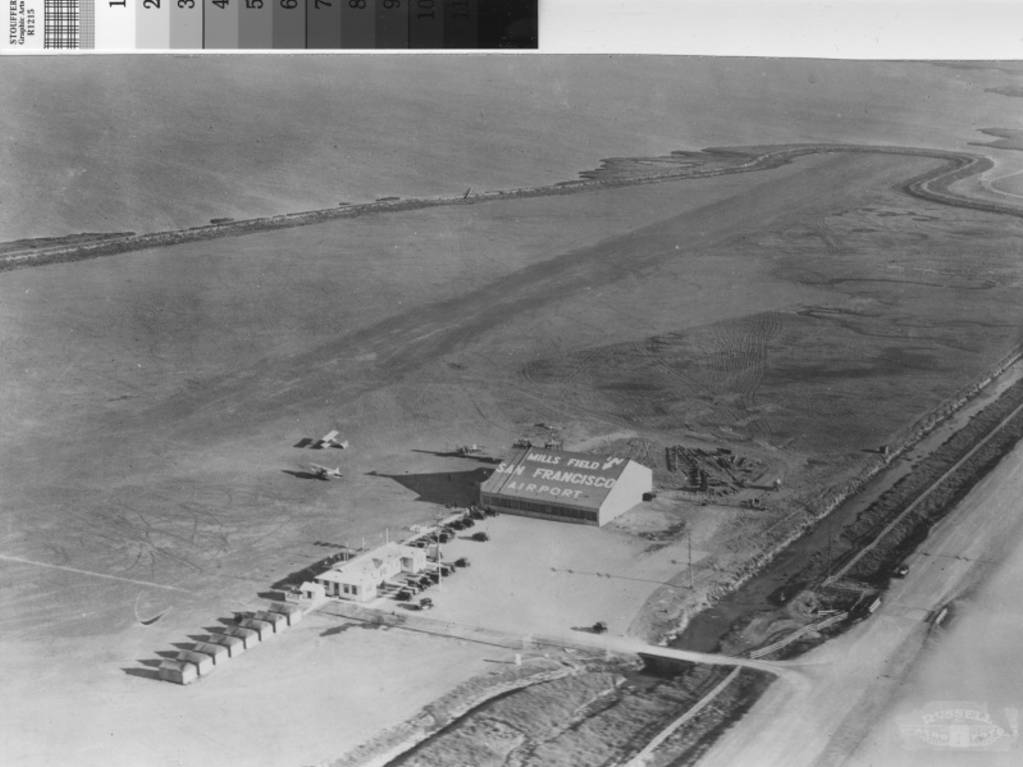 |
| Aerial view of Mills Field Municipal Airport, ca. 1927, Creator: Russell Aero Foto (Firm) | Online Archive of California (OAC) - Contributing Institution: San Bruno Public Library |
Well, we all know that ultimately the San Francisco Airport Committee chose to go north in their location decision. Daniel Stafford and the City commissioners must have been presumably disappointed.
[But what a good thing that was for all us who live in the neighborhood today.]
Retired cattleman turned capitalist and real estate developer Abraham G. Frank who had fled his native Holland just before the Nazi invasion, settling in San Francisco, had bought the Redwood City airport from the Michael O'Dea estate in 1941.
Frank signed over a 10-year lease of the 109-acre airport site with an option to buy, to Lee Cox of the Stinson Flying Corporation, in October of the same year. Cox intended to turn it into a Training School for Pilot Instructors for army air corps cadet training centers. The site would also include an aircraft mechanics school for those seeking accreditation, as well as training facilities for private pilots on Aeronca craft and Stinson planes manufactured by Vultee. Redwood City was to become the pacific coast headquarters for the Stinson Flying Corp.
| ||
| Sources and References: |

- San Mateo Times and Daily News Leader, December 7 1926
- San Mateo Times and Daily News Leader, November 13, 1926
- Redwood City - Local History exhibit on "Climate Best" slogan
- Cunningham Report. pp. 47- 51. Fourth Report of the Navy Yard Commission. May 28 1917, Congressional Serial Se, Issue 7158, pub. Washinton Government Printing Office.
- Airway Bulletin, Issue 2, Descriptions of Airports and Landing Fields in the United States, U.S. Government Printing Office, 1934
- Abandoned and little known Airfields, by Paul Freeman. Link to his info on Sanders Field Airport here.
- Short biography on Walter Varney
- Biographical reference links and information on Silas Christofferson
- OAC Online Archive of California - Mills Field Airport, San Bruno,