Showing posts with label 1910s. Show all posts

The Friendly Butcher

So what is the Severn Dairy Mural in Burlingame, CA, doing on a blog about a neighborhood in Redwood City?
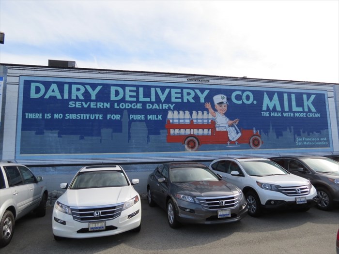
Severn Lodge Dairy Mural, Burlingame, CA - waymarking.com
Naturally, there is a connection.  Firstly, its a segue from our last post on the Murals of Redwood City and mural of Friendly Acres, wherein we stressed the point that murals are not only beautiful but they bring the past alive   And secondly, the connection has everything to do with the livelihood of Harry Friend who founded the Friendly Acres neighborhood here in Redwood City.

In a small clip buried in the The Times from May 14, 1937, in the "Do you Remember Section", a tiny blurb entry is posted under "Twenty Years Ago Today".  It reads "Harry Friend and M. Silva of San Mateo and San Bruno, respectively, had purchased a herd of 149 Holstein cattle from the Severn dairy."

The Times and Daily News Leader, Burlingame, San Mateo, CA p.10, Friday 5/14/1937
The information this provided was a clue as to Harry Friend's dealings in the early decades of the 20th century.  Indeed, what was interesting about the purchase was that it clearly must have been important to be remembered by the newspapers twenty years later.

Friend had bought the cattle in 1917, which is around the time when the Severn Lodge mural is believed to have been painted.  The mural was created to advertize the Severn Dairy Creamery on California Drive, as well as the Milk Delivery company.

The purchase was also of note because it occurred at the peak of World War I,  and a month after the United States decided to join the Great War.  The average price per head, all ages, of cattle other than milk cows, was $35.92 in 1917 and sky rocketed almost 25% to $44.22 in 1919.

And Friend made the purchase not just with anyone, but with Manuel Silva, the son of the renowned rancher Custodio Silva.

Mr. [Custodio] Silva, of Silva Ranch, San Bruno, 188-? Online Archive of California - Contributing Institution: San Bruno Public Library, 
The Silvas had established themselves since the 1880s as ranchers on the Peninsula with various properties in and around the San Bruno and Millbrae areas - and were known most especially for their horse ranch close to the Tanforan thoroughbred RaceTrack.  Horses, and horse power, at the turn of the century were still the predominant mode of load pulling and transportation, everywhere, not just on farms.

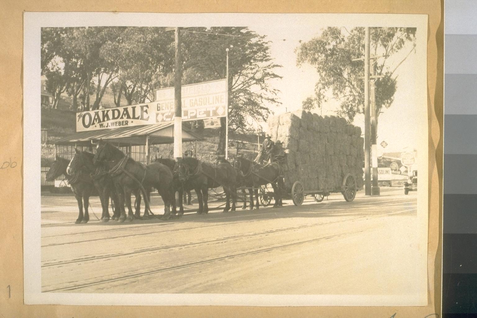
A seven horse Hay Wagon cor. San Bruno Ave. & Oakdale Ave. On its way to the stock yards at Butcher Town. April 6 1928; OAC, Contributing Institution: UC Berkeley, Bancroft Library
For Harry Friend, the joint transaction with Silva for the Holsteins wasn't for dairy farming so much as for the Slaughterhouse which he operated in San Bruno.  The buying and selling of hides was an offshoot by-product venture which he also ran.

Cowboy corralling cattle at Butchertown in 1921.  Photograph dated  Jan 11 1921.
Source: San Francisco History Center, San Francisco Public Library
It turns out that Friend was a butcher by trade.  He had arrived in the U.S. on Nov 13th 1901, age 26, from Kalisz, Poland, and his arrival records at Ellis Island, indicate his occupation as butcher.  His departure records from Hamburg corroborate not only his age but also his occupation as a "Fleischergeselle", which translates literally as "Journeyman Butcher".  (Note: A journeyman is not an Apprentice, but neither is he a Master of his trade.  A journeyman, comes from the french for "journée", meaning "day",  and meant someone who was hired by the day, i.e. paid on a daily basis, and not salaried.  Typically, they would be hired or contracted out to master tradesmen to fulfill a job.)

Immediately on arrival at Ellis Island, his name would be changed to the anglicized "Harry Friend" from the German "Abraham Freund", as per the departure records from Hamburg and ship's manifest of the SS. Milano.  Thereafter, he would use his arrival date in the U.S. as his date of birth, intentionally shaving off five years from his age.  Presumably this was to improve his job prospects in his newly adopted country - in essence creating a new identity and a new life for himself and his family. 

After leaving Ellis Island and settling down in Brooklyn and Manhattan, we know from the 1905 New York City Census records that Friend was already occupied as a Butcher there.  He moved west to San Francisco with his wife, child, and younger brother Solomon, shortly after.

By 1910 the family were living in Vista Grande, which, a year later in 1911, would become known as Daly City. (Vista Grande was a refugee village which had sprung up on a hillside known as Daly's Hill on John Daly's dairy farm, where people fleeing the 1906 San Francisco earthquake began to erect semi-permanent and permanent structures.)

While living in Vista Grande, Friend was working as a self-employed hide buyer and broker.  Hides were a cash commodity and typically hide buyers were employed by the local tanneries.  Smaller tanneries would buy their raw material from reliable slaughterer brokers or receivers that they could trust.  Friend's experience as a butcher/slaughterer made him a valuable asset to many businesses that relied on the raw materials, not just hides and skins, from cattle and livestock.

He still maintained a butcher's business and in 1917, Friend is registered with a licensed slaughter house in San Bruno.

The records indicate he continued on in business as a Butcher until 1922, around his mid-40s when he took up real estate full time.  His daughter, Eva, who was also his bookkeeper ended up marrying within the trade, to Jean Bercut, of the famed Bercut Brothers.  The Bercuts emigrated from Limoges, France, in 1906, and Henri and Pierre, Jean's brothers, opened their first butcher's shop, "Grand Market" in San Francisco in 1912.  They went on to establish the nationally famous Grant Meat Market, located at 743 Market Street, at the tail of Grant Ave where it runs into Market Street.  The Bercut Bros. were known to have the finest meat market in the United States, their reputation having been made initially on boneless cuts of beef.
San Francisco Chronicle, 17 Dec 1912

They eventually relocated to Chestnut Street and in the 1960s the old Meat Market on Grant was turned into a parking lot.


References:

  1. Horse Hay wagon Image:   http://content.cdlib.org/ark:/13030/tf4m3nb5h4/?docId=tf4m3nb5h4&layout=printable-details | 7 horse hay wagon
  2. Lead Steer Image:   http://content.cdlib.org/ark:/13030/tf4489p21v/?query=butcher%20town&brand=calisphere - Lead Steer
  3. Custodia Silva Image:  http://www.oac.cdlib.org/ark:/13030/kt938nd5qr/?docId=kt938nd5qr&brand=oac4&layout=printable-details | - Online Archive of California ; California Digital Library
  4.  Sausalito News, Vol 37, # 27, 2 July 1921 - Much Loss in Beef Cattle | http://cdnc.ucr.edu/cgi-bin/cdnc?a=d&d=SN19210702.2.19.1#
  5. Severn Lodge Dairy Mural, Burlingame - Waymarking.com
  6. Severn Lodge - The Founding Families of Burlingame-Hillsborough blog
  7. Severn Dairy - https://burlingamememories.wordpress.com/exhibitions/severn-dairy/
  8. Henry Pike Bowie and Severn Lodge in article "Jeffer Daykin: Henry Pike Bowie & the "Daimyo" Gate" Aug 17, 2009 in  Half Moon Bay Memories & El Granada Observer, Created by June MorrallHamburg Passenger Manifest Oct 1 1901, Milano Ship, Ellis Island Foundation Passenger Search. http://libertyellisfoundation.org
  9. Cattle Brands and Licensed Slaughterers of 1918 - Showing all recorded Cattle Brands and the names and addresses of all licensed slaughterers on record in the offiÅ“ of the Cattle Protection Board of California - published by the Cattle Protection Board of California., 1919
  10. California Census and Voter Registrations


Sweeny Ranch Airport

The residential development of Friendly Acres in the early 1930s carved up the last of the ranches in the southeastern end of San Mateo County - the notable Sweeny Ranch.  This was in fact the last of the Arguello marsh lands from the old Pulgas rancho.

From about the 1880s the lands just south of Redwood and east of Menlo Park were known as Sweeny Ranch lands, after Myles D. Sweeny who bought the property from the Arguello estate when the Pulgas Rancho went up for sale and was subdivided.  Today, the Sweeny name survives - but just barely. 

You can find it in the land titles of the unincorporated properties in the Sweeny Ranch subdivision in Menlo Park, south of Marsh Road and east of Bay St.  Only about a dozen houses remain today that can still lay claim to being on the historic Sweeney Ranch and they're in unincorporated Redwood City and Menlo Park.

And it continues on in the name of the train stop at Marsh Manor, which still exists today, as a flag stop station - listed in the Southern Pacific railroad schedules, as Sweeny Ranch station.  Yes, that train barrier across Marsh Road is in fact a flag stop station.  But more on that in another post.

And the name continues to exist in the name of Sweeney Ave,  a road just off of Bay Road, opposite the Ampex campus, named after Miles D. Sweeney.  [Editor's note: the variation on the spelling of Myles Sweeny's name in the historical records is common.  The given spelling, based on the 19th Century census records, is without an "e" before the "y".

Today's post, however, is not about the landowners of the rancho lands that Friendly Acres grew out of, but of the airport that we once almost became. 

At the turn of the 20th century, aviation and cars were the huge technological advances which revolutionized transportation and catapulted the world into the modern era.  And from 1911 thru the decade of the roaring 20's, Redwood City was THE place to be on the San Francisco Peninsula if you wanted to watch an airshow or learn to be an aviator.

In the winter of 1926 the San Francisco Airport committee had a shortlist of eight sites to visit - on both sides of the bay, with three of them being in San Mateo County: Coyote Point, Brewer's Island and Sweeny Ranch.

Mr. E. W. Holt, spokesman for the Redwood City Chamber of Commerce encouraged the San Francisco Supervisors to inspect the Sweeny Ranch site describing it as follows:  "The climatic conditions are perfect, insuring perfect flying weather at all times."

Doesn't that sound familiar?  It should.  He was paraphrasing the "Climate Best by government Test" slogan that the City had only recently adopted in the previous year, in 1925, and had placed over their gateway arches into town.

The strategic importance of "climate" as a resource was a big deal to the Peninsula Cities who were interested in attracting San Francisco workers and residents to its green commuter belt and weekend suburban country homes.  Redwood City already had the Redwoods as a business and marketing commodity in its name.  Not being plagued by fog, all it needed was a branding slogan for its perfect weather.  And it intended to capitalize on its micro climate as a strategic resource.

The so-called government test of 1912 was conducted in tandem with the German government, and its likely that the chamber of commerce rallied to have Redwood City submitted as a test site.  And its highly conceivable that Daniel Stafford, one of the city's most influential merchants and business men, was a strong advocate for having the city used as a test site at that time.  The push to market the weather with empirical findings was something that smelled of Daniel Stafford - as the city's largest merchant and a significant real estate and insurance investor he was also one of its biggest promoters.  The climate slogan wasn't just about immortalizing a government report, it was about bringing in big business, big money and big residents.

The Sweeny Ranch site was a late entry to the airport selection game and consisted of 487 acres of marsh land (7000 feet long and 3000 feet wide), which Stafford had recently purchased, located along the Dumbarton cutoff of the Southern Pacific railroad.  (This was the area later to be known as Friendly Acres.)

Image showing Redwood City Airport / Sanders field and Sweeny Ranch lands / Friendly Acres still intact.  An undated aerial view looking east from The Airport Directory Company's 1938 Airport Directory (courtesy of Jonathan Westerling).  The Dumbarton rail line crosses diagonally at the top right of the photo.  Image source from a fantastic site at: Abandoned and Little known Airfields: CA-San Jose area curated by Paul Freeman.
 
Stafford's Sweeny Ranch airport would include the eastern end of Lynch Field, (today the Ampex lands) extending the Sanders Field air strip, which was the existing Redwood City Airport that stretched from Chestnut to Woodside Road.  That eastern end went from Woodside Road to 2nd Avenue, making use of grassland that was being used for grazing cows.

Lynch field was named after Michael Lynch who had purchased a subdivision of the Sweeny Ranch from Regina Pescia (nee Regina Anastasia Sweeny, daughter of Myles D. Sweeny)  in 1898, and used it as a secondary nursery location to grow flowers and cultivate seedlings for the flower trade.

Michael Lynch died in 1905, and his family sold it in June of 1916 to Silas Christofferson, the famous aviator and plane engineer who, aided and abetted by the Redwood City Chamber of Commerce, established his flying school in 1916.

Christofferson had planned to expand and develop the Redwood City airport to the southern end of Lynch field (where Broadway today continues from Woodside Rd to 5th Ave), with a view to manufacturing military airplanes. (In Europe, WWI was at its peak - and Christofferson had ideas for specialized engines and aircraft based on his experience flying for Pancho Villa's army in 1915 during the Mexican Revolution).  But on Halloween of 1916, while test flying a new military plane which he had designed, over the Bay around Redwood City,  the plane's engine died.  Unable to coast it, the plane nose dived and he dropped 100 feet down on to Lynch field, crashing to his death just 4 months after purchasing the fields and airstrip. The young daredevil and brilliant aeronautical mechanic, was only 26.  The airfield was subsequently referred to as "Christofferson field".

Following the tragedy which made international headlines, Frank Bryant who had worked for Christofferson as chief trainer of the flying school, bought out the airport property, and renamed it the Redwood City School of Aviation.

But only three years, later, in 1919, Bryant sold out to the ambitious Walter Varney who had other fields in San Mateo and had ambitions to run a postal air distribution service from San Mateo, as well as aerial taxi services.

Varney also shipped flowers by air from the greenhouses of Redwood City and was subsequently to become  the founder of United Airlines and co-founder of Continental.  During Varney's time until the early 30s when the land was again sold off, the air fields were also referred to as Varney's field

San Mateo Times, November 13 1926
The Redwood City Chamber of Commerce, together with Stafford who had become a Member of the Redwood City Board of Trustees only 3 months previously, offered up the land at $1,000 an acre and promised that it could be made fit for flying conditions in a short space of time - and that the only impediment, they could find was a telephone pole line that crossed the ranch, which could be moved quite easily.

Despite the weather, it all came down to location, location, location.  Aviators of the time seemed to favor a San Francisco-Oakland airfield.   And the distance from San Francisco, regardless of the fog, was the primary reason why Mills Field in San Bruno ultimately won out.  Today, with the delays in takeoff due to the fog, some may question the wisdom of that decision.

Aerial view of Mills Field Municipal Airport, ca. 1927, Creator: Russell Aero Foto (Firm) |
Online Archive of California (OAC) - Contributing Institution: San Bruno Public Library

Well, we all know that ultimately the San Francisco Airport Committee chose to go north in their location decision.  Daniel Stafford and the City commissioners must have been presumably disappointed.

[But what a good thing that was for all us who live in the neighborhood today.]

Despondent with losing the airport bid, Stafford sold out to outside developers who purchased the adjoining eastern side of Lynch field and adjoining lands to Marsh Road, intending to build a project which they called the" Sweeny Ranch subdivision" which would include Friendly Acres, Belle Haven and Dumbarton Acres.

Retired cattleman turned capitalist and real estate developer Abraham G. Frank who had fled his native Holland just before the Nazi invasion, settling in San Francisco, had bought the Redwood City airport from the Michael O'Dea estate in 1941.

Frank signed over a 10-year lease of the 109-acre airport site with an option to buy, to Lee Cox of the Stinson Flying Corporation, in October of the same year.  Cox intended to turn it into a Training School for Pilot Instructors for army air corps cadet training centers.  The site would also include an aircraft mechanics school for those seeking accreditation, as well as training facilities for private pilots on Aeronca craft and  Stinson planes manufactured by Vultee.  Redwood City was to become the pacific coast headquarters for the Stinson Flying Corp.

Notes:
  1. Probably the best description we have for the Sweeny Ranch or Sanders Field airport, in terms of its size and location from Redwood City's business center, is in the Airway Bulletin of 1934.  Sanders Field is described as:  "Sanders Fieldcommercialrating auxiliary airportSix city blocks E. of business centerAltitude10 feetRectangular5,200 feet by 1,200 feetsodlevelnatural drainageone runway4,700 by 350 feetentire field also available."
    Airport Advertisement in the San Mateo Times, Dec 13 1930

  2. Even the U.S. Marine Corps back in 1916 in their survey scouting for possible naval aviation fields around the Peninsula had determined that there were really only 2 suitable locations in the Bay area for flying fields:  Mare Island which the navy already owned, and the location today known as Seaport Boulevard in Redwood City.  Mare Island was preferred as it was already owned by the Navy.  But Redwood City's Seaport area was considered to be far superior than even any other possible site further south in the State that the navy might be interested in and could be used as a naval aviation training base.   First Lieutenant Alfred A. Cunningham who scouted the Peninsula in 1916 for possible naval aviation base locations, concluded in his report however that the marshlands around Redwood City were cut up entirely by sloughs and did not possess enough advantages for aviation purposes unless they were filled in.  He had scoped out 3 sites in Redwood City - the Seaport Blvd marsh land, the Salt Beds south of Seaport (the area today owed by Cargill) and the adjoining Marshes and marsh lands south of there.  The Sweeny Ranch lands were likely included in the marshlands assessment.
  3. At the close of war in 1945, David Bohannon attempted to resurrect the idea of an airport at Friendly Acres but the idea was firmly shut down by residents both from Friendly Acres and Atherton.  (Read more here on Bohannon's Friendly Acres airport.) 
  4. While Redwood City Airport no longer exists, there is one building that still remains from those early halcyon days, originally known as the Aviation Cafe, today the Apatzingan restaurant. (Read more here on Vestiges of Redwood City Airport.)  
Sources and References: